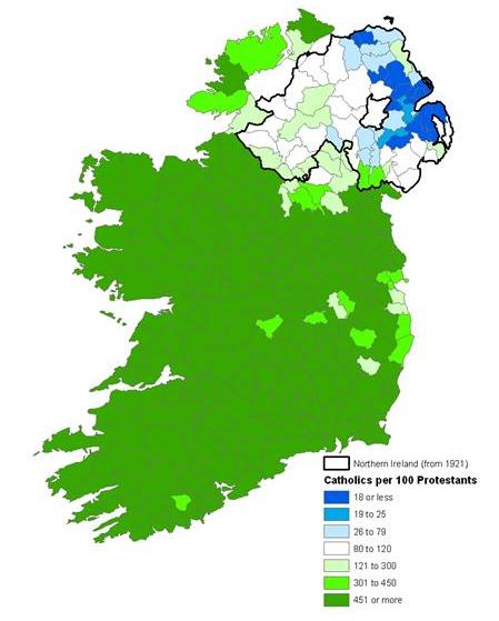
Troubled Geographies:
Two centuries of Religious Division in Ireland
|
Troubled Geographies:
|
|
| Home | Summary | Publications | Social Explorer | Acknowledgements | ||||||||
The Plantations: Sowing the seeds of Ireland's religious geographies
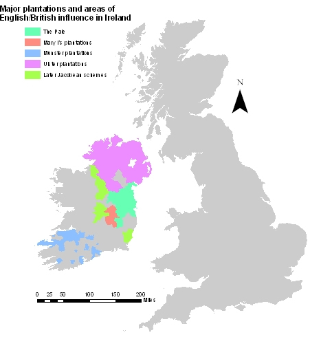
The process of colonisation of Ireland during the sixteenth and seventeenth centuries is commonly known as ‘The Plantation of Ireland.’ This term perhaps gives the false impression that the process was an organised, long-term plan with clear over-arching objectives. In fact it was anything but; it was more often reactive than proactive, disorganised and incoherent but its piecemeal nature has left a deep and enduring imprint on the religious landscape of Ireland. Changing priorities, circumstances and values over time mean that it is impossible to view the process of colonising Ireland as methodologically and ideologically consistent. It is this very inconsistency of approach and impact which largely explains Ireland’s contemporary religious geographies and has resonated down through the centuries.The map below summarises the main phases of plantations in Ireland starting with the Pale, which dates back to the late twelfth century, then through Mary I's plantations of the midlands after 1556, the Munster plantations from 1585, the Ulster plantations of 1603, and then subsequent Jacobean plantations, and the Cromwellian land settlement.
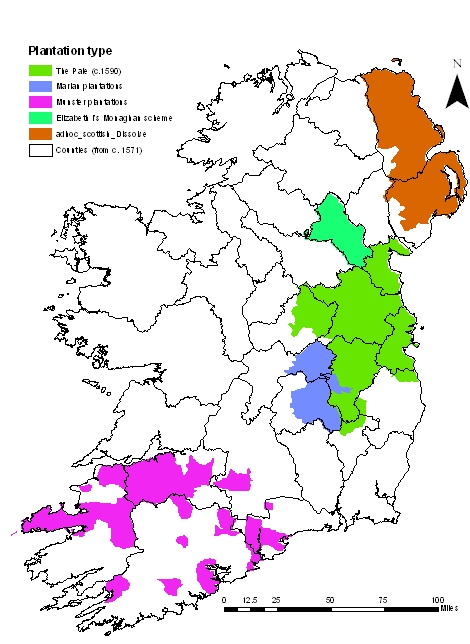
Major plantation schemes and areas of English/British influence in Ireland in the late sixteenth and early seventeenth centuries.BackgroundThe late medieval/early modern period marked a fundamental turning point in Anglo-Irish relations. Prior to the reign of Henry VIII, English control of Ireland had remained in many respects a largely nominal affair. For centuries power had been exercised through crown representatives who were members of the aristocratic elite known as the 'Old English,' descendents of the Norman families who had moved into Ireland in the late twelfth century. After the Wars of the Roses, when various Irish earls supported the losing House of York, the Tudors become increasingly concerned about the threat that Ireland posed to English security. Following a rebellion in 1534 Henry VIII declaring himself King of Ireland signaling the beginning of a much more aggressive English colonial posture in Ireland. The plantation of Ireland must be understood not only in the context of the potential threat of instability which successive monarchs regarded Ireland to be, but also in the light of the theological revolution which was to redefine Europe’s religious landscape and to more profoundly radicalise relationships between the two islands. The fact that Ireland remained Catholic while Britain turned towards varying degrees of Protestantism introduced a new and complex dimension into Anglo-Irish relations which would provide the basis for a far higher degree of mutual distrust and suspicion than was ever possible before. The Midlands Plantation (1556)The first major plantation scheme occurred in the midlands from 1556. It was initiated by Mary I in the areas corresponding to the modern counties of Laois and Offaly, known as Queen's and King's counties before Partition. The aim of the the scheme was to protect 'the Pale,' the area around Dublin that was the main centre of English authority in Ireland, by establishing two large settlements at Maryborough (modern-day Port Laois) and Philipstown (Daingean). In this the scheme was partly successful, however rather the new settlements became the focus for attacks by native chiefs and as a consequence became quasi-military settlements requiring support from the English exchequer rather than self-financing civilian colonies. Despite the fact that Mary was a Catholic, much of the settlement was largely Protestant in character. There were also strong ethnic aspect to the scheme as land confiscated from natives was to be settled by 'Englishmen born in England or Ireland' [ref] thus religious and ethno-national identities in Ireland were beginning to fuse into two antagonistic identities. The Munster Plantation (1585)An unsuccessful rebellion by the Catholic Earl of Desmond in 1585 led to his lands across the province of Munster being confiscated. War and famine had led to these areas being under-populated, and settlers, mainly from the west of England were brought in to re-populate the area.
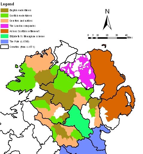
The Tudor plantations of IrelandAs the map above shows, the lands confiscated were piecemeal across Munster. The process of colonising the areas was also painfully slow such that by 1598 only around 12,000 people had settled. To confuse this pattern further many displaced former residents reclaimed their land either legally or by squatting. A rebellion in that year hit the plantations hard but after this they recovered and by 1641 there were estimated to be a settler population of around 22,000. The significance of the Munster plantation is that it left a large Protestant minority in south and west Cork. In other parts of Munster its legacy is harder to discern perhaps because of the degree of mixing and inter-marriage that occurred. The Ulster Plantation (1603)Ulster had long been the most volatile and underdeveloped of Ireland's provinces. It also had well established ties across the North Channel to Catholic clans in Scotland which presented a strategic threat to England. The scheme focused on the counties west of Lough Neagh and the River Bann in an attempt to break up the old centres of Gaelic influence in these areas. The plan was to give much of the land to English or Scottish 'undertakers' who would settle their land with Protestants. The remainder was to be given to 'servitors,' native Catholics who had shown loyalty to the crown during the Nine Years War. The plans for the county of Coleraine were different in that responsibility was passed to the guilds of the City of London leading to the county being renamed Londonderry. Antrim and Down were excluded as they had already been the subject of successful private plantation schemes.
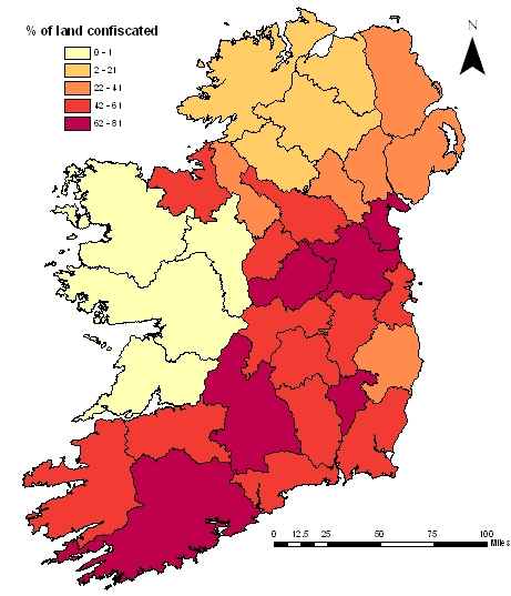
The map above shows a very aggregate plan of most of the six counties that formed the organised plantations. A major issue was that the new plantations contained far more Catholics than originally intended. This resulted in both Catholics and Protestants feeling that their positions were imperiled but this was particularly acute among native Catholics who were rarely granted land in areas that their clans had traditionally occupied. To confuse this, however, the religious segregation that the plantation had originally envisaged proved impractical as agricultural and economic forces made the groups mutually dependent. Had the Ulster plantation fully succeeded it would have imposed a completely new religious geography and created a new social, economic and religious landscape in which the native population would have been assimilated. This was only partially achieved and new geographies were created which remain to this day. Much of western Ulster still forms the heartland of the Church of Ireland while Antrim and Down still bear the imprint of organised and ad-hoc migration of Scottish lowlanders who brought Presbyterianism with them. However, rather than fostering amity between Catholics and Protestants, the economic and political dispossession of the Catholic population of Ulster started a festering resentment which endured for the next three centuries. While the new geographies brought Catholics and Protestants into closer physical proximity, socially, economically and religiously they moved increasingly apart. The Cromwellian Land Settlement (1652)In 1641 Catholics in Ulster rebelled killing several thousand of their Protestant neighbours. This, along with the Siege of Derry in 1689, would calcify into Protestant mythology the image of Catholic savagery and barbarirty. [ref] In response Oliver Cromwell took his revenge in the south, massacring civilian populations in Drogheda and Wexford in his campaign of 1649-50. This was followed by the final piece of the plantations jigsaw which has done much to define the spatial distributions of Ireland's three main religious groups.
The Cromwellian land settlement (After Cornish, 1976) In 1641 Catholics still owned 59% of Ireland's land [ref]. Cromwell's plan was to clear all Catholics from east of a line stretching from the Barrow to the Boyne rivers, however, a lack of British settlers led to new Protestant landowners arguing for a Catholic working class to be retained. Again, therefore religious segregation was a core idea of this phase, but again it proved unworkable. Nevertheless, as the map above shows, the land settlement did have a major impact in reducing Catholic land ownership in the east of Ireland. ConclusionsIt is impossible to over-estimate the impact of the plantations in defining Ireland and its religious geographies in the modern period. The plantation of Ulster in particular succeeded in transforming the religious complexion of the island, while the Cromwellian land settlement permanently marginalised Catholics both economically and theologically whilst cementing the Protestant ascendancy in Ireland. And while religious segregation was often at the heart of the colonisation ideal, it is clear that the theory did not reflect the practice of plantation. Nevertheless, the plantation of Ireland did create a tension resulting from mutual distrust and fear, yet also interdependence. This was the real start of what the historian F.S.L. Lyons has described as an anarchy of the heart and mind, ‘of the collision …of seemingly irreconcilable cultures, unable to live together or to live apart, caught inextricably in the web of their tragic history.'
|
||||||||||||
|
|
|
|
|